Why it's warm in Alaska but frigid in most of the U.S. right now

The cold front that is sweeping across the entire eastern half of the U.S., from Colorado to Virginia, is no ordinary weather boundary.Instead, it's a front on steroids, bringing with it a near-instantaneous switch from summer temperatures to winter, complete with howling winds, heavy snow and even dust storms. And the cold air the front is ushering in shows no signs of leaving anytime soon.
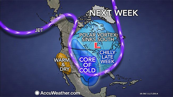
Arctic invasion: Unusual cold air sweeping into the U.S. is here to stay. Thanks to an unusually contorted jet stream, the weather map looks as though the Arctic has picked up and temporarily relocated to the lower 48 states, leaving the actual Arctic unusually mild. Based on computer model projections, the Arctic may be a long houseguest, as the pattern is projected to last for at least a week and a half, and likely longer than that. The weather pattern is leading to a classic episode of what climate scientists have labeled the "warm Arctic, cold continents" pattern, something that has been seen with increasing frequency in recent years. Studies have tied this particular pattern in part to rapid Arctic climate change as a result of manmade global warming, although this is still a subject of debate within the mainstream climate science community.

Right now, the jet stream, which is a highway of air at about 30,000 feet that steers storm systems and separates air masses, is contorted like a boa constrictor. The North Pacific jet stream is being redirected northward, up and over Alaska, thanks to a strong ridge of high pressure parked over the western U.S. The jet stream then nosedives like a roller coaster, from northwest to southeast across northern Canada and deep into the southern U.S., thereby allowing pure polar air to surge southward, into the U.S. from Canada.
The effects of this weather pattern have already been astounding.
The cold front dividing the Arctic air to the north and the mild air to the south has been slicing across the continental U.S., dropping temperatures by at least 30 degrees Fahrenheit in just 30 minutes in some places. In Denver, Colorado, Monday began with mild conditions and a temperature of 64 degrees Fahrenheit. By mid-afternoon, it was snowing with a temperature in the 20s (Fahrenheit).In some places, including southeastern Colorado and the Texas Panhandle, the cold front was accompanied by a large dust storm, also known as a haboob.
The cold front is slated to reach the East Coast by Wednesday night, marking the early arrival of winter in the big cities of Washington, D.C., Philadelphia, Pennsylvania and New York City.
Weather pattern has turned upside down
The jet stream pattern has effectively reversed typical seasonal norms at this point, with Alaska seeing considerably milder conditions than many parts of the lower 48 states.
Consider this:
As of 10:30 a.m. ET, it was already warmer in Barrow, Alaska, where the sun had not yet inched above the horizon, than it was in Denver, Colorado. (The average high for early November in Barrow is 8 degrees Fahrenheit.) More than a foot of snow fell in Michigan on Monday and Tuesday, but Anchorage, Alaska, experienced slick roadways from rain showers. Some towns in Alaska and northwest Canada are setting warm temperature records, while cold records are threatened in the continental U.S. For example, in Kotzebue, Alaska, which is in the far northwest part of the state, a record high minimum temperature was recorded on Nov. 10, when the temperature failed to fall below 32 degrees Fahrenheit. This beat the old record of 28 degrees Fahrenheit, which was set in 1997, according to the National Weather Service.
On Monday and Tuesday, more than a foot of snow fell in parts of the Dakotas, eastward to Minnesota and Wisconsin. Yet in Anchorage, Alaska, forecasters warned of slick roadways due to rain showers.
According to the National Weather Service (NWS) forecast office in Fairbanks, Alaska, temperatures there are expected to be as much as 14 degrees Fahrenheit above average by Wednesday, which would set a record high. Temperatures in the upper levels of the atmosphere, at about 18,000 feet, are extremely warm for Alaska at this time of year, forecasters said in an online discussion. The NWS says the temperatures "are near normals for July... not November."
On Tuesday, the forecast high temperature in Fairbanks is 33 degrees Fahrenheit, which is just five degrees below the record for the date, the NWS said. Compare this to the forecast high temperature in Kansas City, Missouri, on Tuesday, which is just 16 degrees Fahrenheit. Temperatures across parts of the Central states on Tuesday will average between 20 and 40 degrees Fahrenheit above average, while Alaska, northwest Canada, and parts of the central Arctic experience the opposite temperature anomalies.
The chain of events leading to this cold wave can be traced in part back to
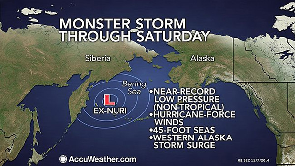
Super Typhoon Nuri, which enhanced the North Pacific jet stream as the storm spun out sea east of Japan. During the weekend, Nuri was given a second chance at life, this time as
one of the strongest (non-tropical) storms ever observed in the Bering Sea.
The counterclockwise circulation around this storm pumped a lot of mild air over Alaska and northwest Canada, and strengthened an area of high pressure in this region. The strong area of high pressure is effectively blocking incoming weather systems and forcing them to go up and around it, like a detour along a highway. This ridge, meteorologists say, is helping to displace extremely cold air from the Arctic to the south, into the U.S.
Such a "blocked" weather pattern fits into a
hypothesis that holds that as the Arctic warms disproportionally fast compared to lower latitudes, the jet stream is more prone to high amplitude waves, and blocking patterns like the one taking place now. Such patterns often lead to extreme weather events, from heat waves to cold snaps. The hypothesis is supported by several studies, but the physical mechanism linking Arctic warming and the loss of sea ice there with the jet stream, which exists high in the atmosphere, has not yet been clearly identified.