During the winter months a great amount of protection is provided for our putting surfaces regardless whether the winter time temperatures are at freezing or above. several precautions are taken to help in protecting the plant so that when the spring rolls around the turf is healthy and ready to begin it new growth cycle during the warm season months.
Here's a few examples that you may recognize:
* Height of cut is raised-during the summer months we typically mow the greens between .117 and .109-that's just above a tenth of an inch. During the winter months the HOC is raised to .151 which is equal to 5/32". There's a tremendous amount of difference in turf now available to uptake sunlight, fertilizer, chemical, and protection against freezing weather.
* Growth Regulator is removed-During the warm season months I use a growth regulator to help in growth management which reduces the frequency of mowing and the amount of grass clippings by reducing the vertical growth of the turf. Imagine this; hold you hand up and spread your fingers far apart-this is the size of a leaf blade during the winter months----now, bring your fingers into a fist shape-this is the size of the leaf blade during the summer months under the management of a growth regulator. If you can imagine this magnify this across the entire putting surface. During winter months there's a lot of turf reaching out to grab everything it can to live. During the summer months those leaf blades are shrunk down and in height and width, the smooth rolling know begins and consistentency sets in.
Some of you may say that in the winter time, the ball rolls better and/or faster. Keep in mind that's during cold temperatures, when temperatures start warming up, putting speeds slow down.
* Fertilizers-during the winter months, a granular product is applied every 30 days. I tend to favor the phosphorus and potassium along with micro-nutrients rather than the nitrogen. As an example we apply a 10-20-20 in December, January, and February, 1/2 pound p/1000 sq. ft. of Nitrogen is applied and 1.0 pound p/1000 sq. ft. of phosphorus and potassium is applied. That equals out to 600 pounds of granular fertilizer applied per month. Once March rolls around a decision is based on temperatures, soil moisture levels, has it been a dry year or wet year so far? Then comes soil testing to find out the deficiency in nutrients in the soil and leaf blades.
* Fungicides-For all of you that have been members here for years, I'm sure you can remember the years when #3,4,5, 14, greens & the putting green would lose turf in the late winter months. After the third year of my complications with these same greens plus a few more, I TOOK ACTION. 18 out of 20 greens we found damage drainage and after all the drainage issues were fixed all 20 greens today have held up nicely throughout the year. What a relief!!!
With all that said, a fungicide program was established to help in controlling leaf spot diseases. Every two weeks an preventative fungicide application is made. Once the warm season rolls around I shift to different types of fungicides spraying every 30 days targeting root rot diseases and fairy ring diseases.
There's so much detail that I can go into that has not even been mentioned, but I just wanted to share the basics. I hope you got something out of it and if you really want to get in depth, well come and find me.
Thanks
Willy Plowman
Golf Course Superintendent
Friday, December 5, 2014
Sunday, November 16, 2014
Expected frost delays
As all of you know cold weather has moved in and and is sticking around.
Just a heads up to all:
EXPECT FROST DELAYS
Tuesday November 18th
&
Wednesday November 19th
Tuesday November 18th
&
Wednesday November 19th
Tuesday low is forecasted for 28 degrees. Possible frost delays up to 9:00 or later.
Wednesday low is forecasted for 31 degrees. Possible frost delays up to 8:00 or later.
Of course depending on which local station you prefer or the weather channel; all of them seem to forecast a little different. Let's hope it stays above freezing and only minor delay may take place.
Thanks for your understanding.
Willy Plowman
Golf Course Superintendent
Thursday, November 13, 2014
Why it's warm in Alaska but frigid in most of the U.S. right now

Arctic invasion: Unusual cold air sweeping into the U.S. is here to stay. Thanks to an unusually contorted jet stream, the weather map looks as though the Arctic has picked up and temporarily relocated to the lower 48 states, leaving the actual Arctic unusually mild. Based on computer model projections, the Arctic may be a long houseguest, as the pattern is projected to last for at least a week and a half, and likely longer than that. The weather pattern is leading to a classic episode of what climate scientists have labeled the "warm Arctic, cold continents" pattern, something that has been seen with increasing frequency in recent years. Studies have tied this particular pattern in part to rapid Arctic climate change as a result of manmade global warming, although this is still a subject of debate within the mainstream climate science community.


Weather pattern has turned upside down
The jet stream pattern has effectively reversed typical seasonal norms at this point, with Alaska seeing considerably milder conditions than many parts of the lower 48 states.
Consider this: As of 10:30 a.m. ET, it was already warmer in Barrow, Alaska, where the sun had not yet inched above the horizon, than it was in Denver, Colorado. (The average high for early November in Barrow is 8 degrees Fahrenheit.) More than a foot of snow fell in Michigan on Monday and Tuesday, but Anchorage, Alaska, experienced slick roadways from rain showers. Some towns in Alaska and northwest Canada are setting warm temperature records, while cold records are threatened in the continental U.S. For example, in Kotzebue, Alaska, which is in the far northwest part of the state, a record high minimum temperature was recorded on Nov. 10, when the temperature failed to fall below 32 degrees Fahrenheit. This beat the old record of 28 degrees Fahrenheit, which was set in 1997, according to the National Weather Service.
The counterclockwise circulation around this storm pumped a lot of mild air over Alaska and northwest Canada, and strengthened an area of high pressure in this region. The strong area of high pressure is effectively blocking incoming weather systems and forcing them to go up and around it, like a detour along a highway. This ridge, meteorologists say, is helping to displace extremely cold air from the Arctic to the south, into the U.S.
Such a "blocked" weather pattern fits into a hypothesis that holds that as the Arctic warms disproportionally fast compared to lower latitudes, the jet stream is more prone to high amplitude waves, and blocking patterns like the one taking place now. Such patterns often lead to extreme weather events, from heat waves to cold snaps. The hypothesis is supported by several studies, but the physical mechanism linking Arctic warming and the loss of sea ice there with the jet stream, which exists high in the atmosphere, has not yet been clearly identified.
On Monday and Tuesday, more than a foot of snow fell in parts of the Dakotas, eastward to Minnesota and Wisconsin. Yet in Anchorage, Alaska, forecasters warned of slick roadways due to rain showers.
According to the National Weather Service (NWS) forecast office in Fairbanks, Alaska, temperatures there are expected to be as much as 14 degrees Fahrenheit above average by Wednesday, which would set a record high. Temperatures in the upper levels of the atmosphere, at about 18,000 feet, are extremely warm for Alaska at this time of year, forecasters said in an online discussion. The NWS says the temperatures "are near normals for July... not November."
On Tuesday, the forecast high temperature in Fairbanks is 33 degrees Fahrenheit, which is just five degrees below the record for the date, the NWS said. Compare this to the forecast high temperature in Kansas City, Missouri, on Tuesday, which is just 16 degrees Fahrenheit. Temperatures across parts of the Central states on Tuesday will average between 20 and 40 degrees Fahrenheit above average, while Alaska, northwest Canada, and parts of the central Arctic experience the opposite temperature anomalies.
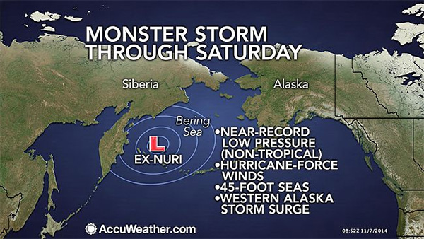
The chain of events leading to this cold wave can be traced in part back to Super Typhoon Nuri, which enhanced the North Pacific jet stream as the storm spun out sea east of Japan. During the weekend, Nuri was given a second chance at life, this time as one of the strongest (non-tropical) storms ever observed in the Bering Sea.The counterclockwise circulation around this storm pumped a lot of mild air over Alaska and northwest Canada, and strengthened an area of high pressure in this region. The strong area of high pressure is effectively blocking incoming weather systems and forcing them to go up and around it, like a detour along a highway. This ridge, meteorologists say, is helping to displace extremely cold air from the Arctic to the south, into the U.S.
Such a "blocked" weather pattern fits into a hypothesis that holds that as the Arctic warms disproportionally fast compared to lower latitudes, the jet stream is more prone to high amplitude waves, and blocking patterns like the one taking place now. Such patterns often lead to extreme weather events, from heat waves to cold snaps. The hypothesis is supported by several studies, but the physical mechanism linking Arctic warming and the loss of sea ice there with the jet stream, which exists high in the atmosphere, has not yet been clearly identified.
Super typhoon and the polar vortex: Why it's about to get so cold in much of the country

Brace yourselves; winter is coming. "Polar vortex" may have been the weather catchphrase of last winter, but it's coming back and it's bringing snow and freezing temperatures along with it.
While it might be easy to look north and blame Canada for sending the polar vortex down into the United States, the real cause behind it is happening thousands of miles to the west. The remnants of Super Typhoon Nuri has made their way from the western Pacific Ocean east of the Philippines, up to the Bering Sea between Alaska and Russia. The storm is expected to bring sting winds and huge waves to the area and may become one of the largest storms to hit Alaska since the 1970s, according to AccuWeather.com.
While it might be easy to look north and blame Canada for sending the polar vortex down into the United States, the real cause behind it is happening thousands of miles to the west. The remnants of Super Typhoon Nuri has made their way from the western Pacific Ocean east of the Philippines, up to the Bering Sea between Alaska and Russia. The storm is expected to bring sting winds and huge waves to the area and may become one of the largest storms to hit Alaska since the 1970s, according to AccuWeather.com.
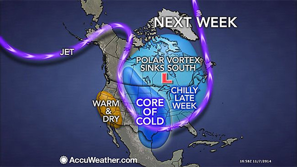
A Bering Sea super storm may not seem like it would impact temperatures in Chicago and Minneapolis, but a storm of that size has the ability to push the jet stream out of position, forcing arctic air that normally sits much farther north down into the U.S. And that is exactly what's expected to happen this weekend.
The cold weather is expected to impact as many as 200 million people as it sweeps across the U.S.
By next week, temperatures in the Plains states could drop 40 degrees or more and freezing air, wind and snow will make their way into the Midwest. The worst of the cold will be felt from Fargo and Minneapolis to Chicago and St. Louis, according to AccuWeather.

The cold will stretch all the way south into Texas and east along the Atlantic Seaboard and may last into the middle of the month.
Perhaps it's time to consider a trip out to California. As the rest of the country shivers under the parkas, the West Coast is expected to remain warm and dry.
Perhaps it's time to consider a trip out to California. As the rest of the country shivers under the parkas, the West Coast is expected to remain warm and dry.
Understanding Frost Delays
The following was presented by the Golf Course Superintendents Association of America.
As winter starts to give way to spring-like temperatures, the desire to hit the golf course intensifies. It also signals a change in golf course management activities that can affect one's game and the conditions found on the course.
In many regions of the country, golfers occasionally face frost delays in the spring, thus pushing back starting tee times. When frost is present golf course superintendents delay play until the frost has melted. This is done to prevent damage that affects the quality of the playing surface and could potentially be very expensive to repair.
Frost is basically frozen dew that has crystallized on the grass, making it hard and brittle. A grass blade is actually 90 percent water, therefore it also freezes. Because of the short mowing height (sometimes as low as 1/8 inch) and fragile nature of the turf, putting greens are most affected by frost. Walking on frost-covered greens causes the plant to break and cell walls to rupture, thereby losing its ability to function normally. When the membrane is broken, much like an egg, it cannot be put back together.
Golfers who ignore frost delays will not see immediate damage. The proof generally comes 48-72 hours later as the plant leaves turn brown and die. The result is a thinning of the putting surface and a weakening of the plant. The greens in turn become more susceptible to disease and weeds. While it may not appear to be much of an issue if a foursome begins play early on frost-covered greens, consider the number of footprints that may occur on any given hole by one person is approximately 60. Multiply that by 18 holes with an average of 200 rounds per day and the result is 216,000 footprints on greens in a day or 6,480,000 in a month.
As golf enthusiasts superintendents do not like to delay play, but they are more concerned about turf damage and the quality if conditions for the golfer. Frost also creates a hardship on a golf facility's staff as all course preparations are put to a halt until thawing occurs. Golf carts can cause considerable damage, therefore personnel cannot maneuver around the course to mow, change cup positions, collect range balls, etc.
One technique employed to reduce possible frost damage is to raise the cutting height of mowers to create a heartier surface. It may also be possible to reroute play to holes where the frost melts more quickly. But regardless of these methods, the best medicine is for all to understand the hows and whys of the delay and in turn gain a greater appreciation for the golf course. It would also be wise to give the course a phone call before heading out to play to see if tee times have been pushed back due to frost.
Thursday, October 30, 2014
Overseeding Driving Range Tee and Tee Boxes
All tee boxes will be overseeded with ryegrass this week. This a winter grass that is planted in the fall to give some color during the winter months when everything is dormant (brown). The driving range will be isolated to the mats for the next 2 weeks so that the winter grass has the opportunity to grow in a consistent manner. Once we have mowed the driving range tee, I'll have it opened and ready for everyone the chop it all up.
Thanks for your patience!
Willy Plowman
Golf Course Superintendent
Thanks for your patience!
Willy Plowman
Golf Course Superintendent
Leveling Tee Boxe #5
Some of you may have already noticed that the white tee box on hole #5 has been tampered with. The golf course maintenance staff came in and removed the sod from the tee top and then leveled the soil. once all elevation levels were shot and agreed upon the staff then replanted the turf back onto the tee top. The staff will then top dress the tee top heavily with sand so that any gaps will be filled and the level of the tee top becomes a better consistency.
From here; will be moving to #7 blue and white tee box and then to #9 white tee. Once #9 is completed the staff will shift to leveling a few of the LADIES tee boxes. So ladies let me know which ones are bothering y'all.
Thanks
Willy Plowman
Golf Course Superintendent
From here; will be moving to #7 blue and white tee box and then to #9 white tee. Once #9 is completed the staff will shift to leveling a few of the LADIES tee boxes. So ladies let me know which ones are bothering y'all.
Thanks
Willy Plowman
Golf Course Superintendent
Future of golf courses?
Golf Course Turfgrass Reduction:
Environmentally and Strategically Sustainable
Many golf clubs are reducing the amount of regularly maintained turfgrass on a golf course. The golf course superinten-dent and a golf course architect should agree on a plan for keeping the strategic intent of the course intact and ensuring appropriate installation of replacement materials. A survey of members of the American Society of Golf Course Architects (ASGCA) revealed 93 percent of respondents are helping their clients reduce the acreage of maintained turfgrass while pre-serving the course’s strategic intent. Here are some examples:
Lowering Maintenance Costs
Before


After
The Planning Process: How a Golf Course Architect Can Help
course archi-tect should carefully consider when irrigation system changes need expert oversight.
Subscribe to:
Posts (Atom)